
Enter your name and email address to receive Gunpoint newsletters
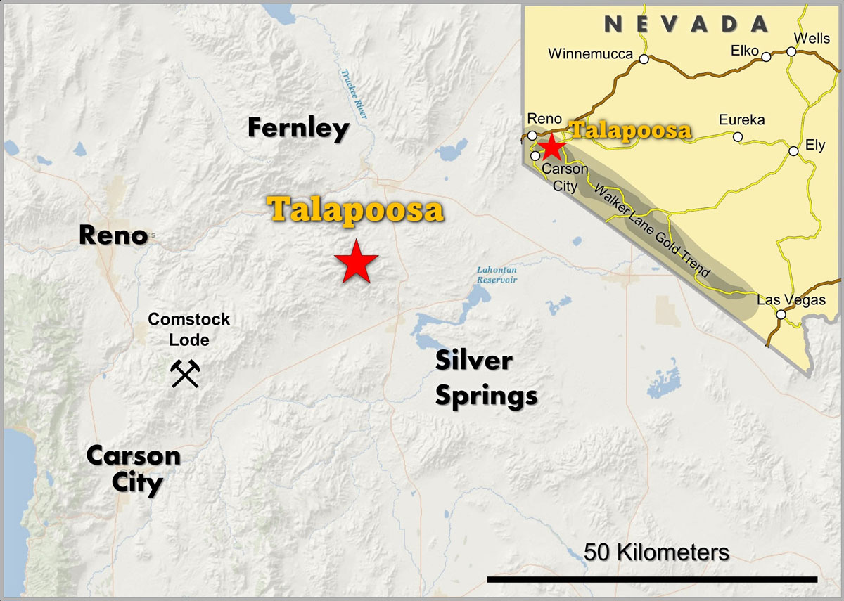
The Talapoosa project (“Talapoosa”) is a low-sulfidation gold-silver deposit in the Walker Lane gold trend of western Nevada, approximately 45 kilometers east of Reno. The Talapoosa land package covers approximately 14,870 acres.
Talapoosa is a volcanic-related, quartz-adularia, low-sulfidation, epithermal gold-silver system. The mineralized area at Talapoosa is approximately 2,200 feet long, up to 1000 feet wide and 500 feet thick down dip. Gold and silver mineralization occurs as quartz-chalcedony veins, hydrothermal breccias surrounded by margins of stockwork veining. The upper 70 meters is predominately oxidized. The deposit is faulted by post-mineral dip slip movement along high angle faults into the outcropping Main Zone and down faulted Bear Creek Zone to the south.
Since 1977, eight mining companies have carried out exploration and development with 564 drill holes totaling 71,000 meters along with extensive metallurgical test work and environmental studies. In the mid 1990’s, Miramar Mining Corporation cited a historic (pre NI-43-101) measured and indicated resource of 42.7 million tons containing 1.06 million ounces of gold and 14.5 million ounces of silver. Miramar permitted and was granted approval to mine Talapoosa. Due to prevailing low gold prices, Miramar did not proceed with the construction of a mine.
In 2011, Gunpoint re-logged approximately 50,000 metres of historic drill core. Subsequently, Gunpoint drilled 7,000 meters comprising seven PQ diamond core holes located along two drill sections. The drill fences, spaced approximately 250 meters apart, provided two representative sections through the Bear Creek zone. The re-logging together with Gunpoint’s drill results led to the re-interpretation of the controls on mineralization at Talapoosa. Historically, the mineralization was modeled as a gently south dipping body of stockwork and disseminated mineralization, roughly coincident with the distribution of the welded tuff horizon. The previous models did not consider post-mineral faulting. Gunpoint interpreted the mineralization as being hosted by a series of steeply south dipping veins and hydrothermal breccias, hosted within a competent welded tuff unit approximately 200 meters thick.
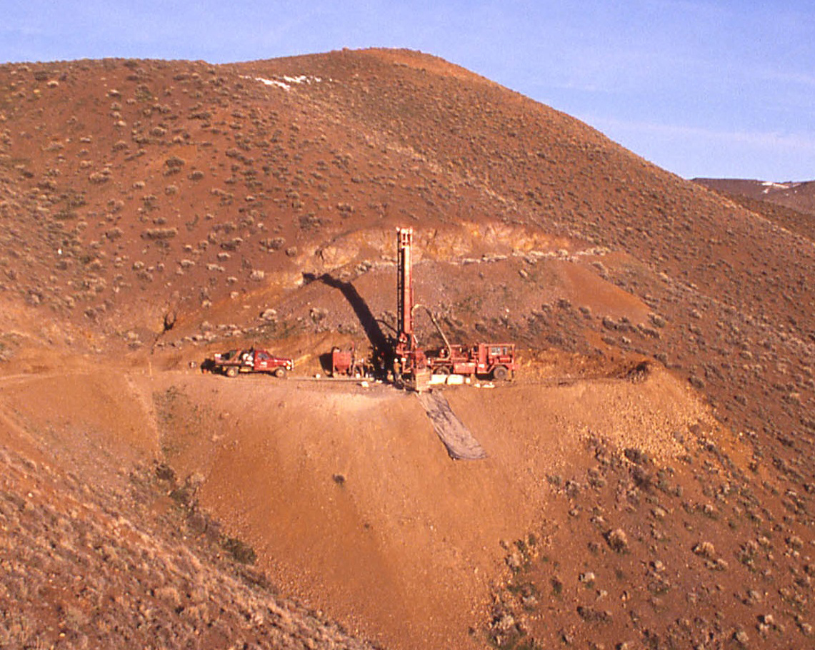
The PQ drill core program was designed to define the vein orientations and provide core for metallurgical testwork. All mineralized material (maximum interval of 5 feet), was split and the half-core was analyzed using Metallic Screen Fire Assay techniques side by side with corresponding 50 gram Fire Assays to determine the influence of nugget effect on overall grade. The comparison of the standard fire assay versus Metallic Screen Fire Assays for individual intervals, demonstrates that standard fire assays, the technique used in nearly all historic drill core analysis, is subject to a nugget effect which appears to result in the potential average grade being understated by as much as 10% to 20%.
In 2013, Gunpoint contracted Tetra Tech to complete a revised NI 43-101 resource estimate. The updated resource estimate added approximately 380,000 ounces of gold and 5.4 million ounces of silver to the previous NI 43-101 resource completed in September, 2010. The increase in both grade and ounces is the direct result of Gunpoint’s re-interpretation of the controls on mineralization. Historic drilling northwest and southeast of the Talapoosa deposit intercepted similar grades of mineralization which were not included in NI 43-101 resource estimate.
Talapoosa Resource Summary
| Cutoff AU g/t |
Ore Type | Category | Tonnes | Grade Au g/t |
Grade Ag g/t |
Contained Gold (ounces) |
Contained Silver |
| 0.445 | Oxide | Measured | 3,126,050 | 1.29 | 18.96 | 117,253 | 1,728,323 |
| 0.445 | Sulphide | Measured | 14,044,820 | 1.22 | 16.50 | 501,215 | 6,760,763 |
| 0.445 | Oxide | Indicated | 1,412,000 | 1.10 | 14.25 | 45,328 | 586,999 |
| 0.445 | Sulphide | Indicated | 12,681,600 | 0.94 | 12.36 | 349,005 | 4,573,274 |
| 0.445 | Oxide | Total M&I | 4,538,050 | 1.23 | 17.49 | 162,581 | 2,315,321 |
| 0.445 | Sulphide | Total M&I | 26,726,420 | 1.09 | 14.54 | 850,220 | 11,334,037 |
| 0.445 | Oxide + Sulphide |
Total M&I | 31,264,470 | 1.11 | 14.97 | 1,012,802 | 13,649,358 |
| 0.445 | Oxide + Sulphide |
Inferred | 11,198,000 | 0.72 | 6.65 | 233,532 | 2,172,766 |
Tetra Tech, 2013.
During 2015-2018, Timberline Resources had an option to acquire Talapoosa. In 2015, Timberline contracted WSP Canada to provide a Preliminary Economic Assessment study ("PEA"). Based on US$1,150 gold and silver at $16.00 per ounce, the PEA indicated an after-tax net present value of US$136 million (5% discount rate) and an IRR of 38.8%. The capital payback was 3.1 years.
Preliminary Economic Assessment
| Mine Operation | Open pit, heap leach |
| Mine Life | 11 years |
| Annual Gold Production | 55,000 oz |
| Annual Silver Production | 679,000 oz |
| All-In Sustaining Cost | $599/oz |
| Initial Capital Cost | $51 million |
| Capital Payback | 3.1 years |
| After-Tax IRR | 38.8% |
| After-Tax NPV (5%) | $136 million |
WSP Canada, 2015
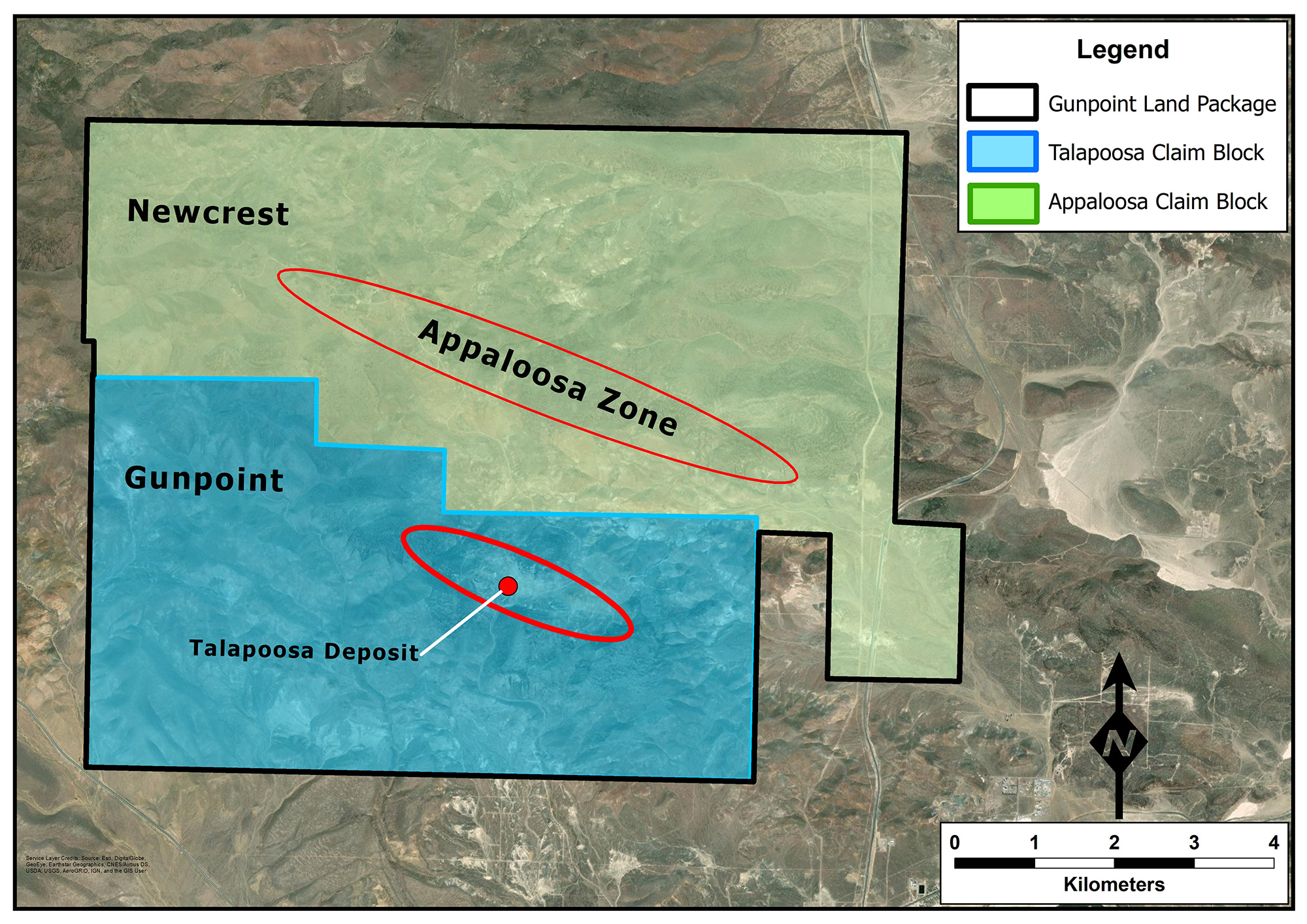
Appaloosa is an unexplored 7 kilometer long mineralized structural zone that is subparallel and one kilometer northeast of the Talapoosa trend. Appaloosa is a broad and extensive hydrothermal system with high level manifestations of epithermal mineralization including sinters, siliceous sediments and vent breccias. Zones of silicification extend up to 300-400 meters wide.
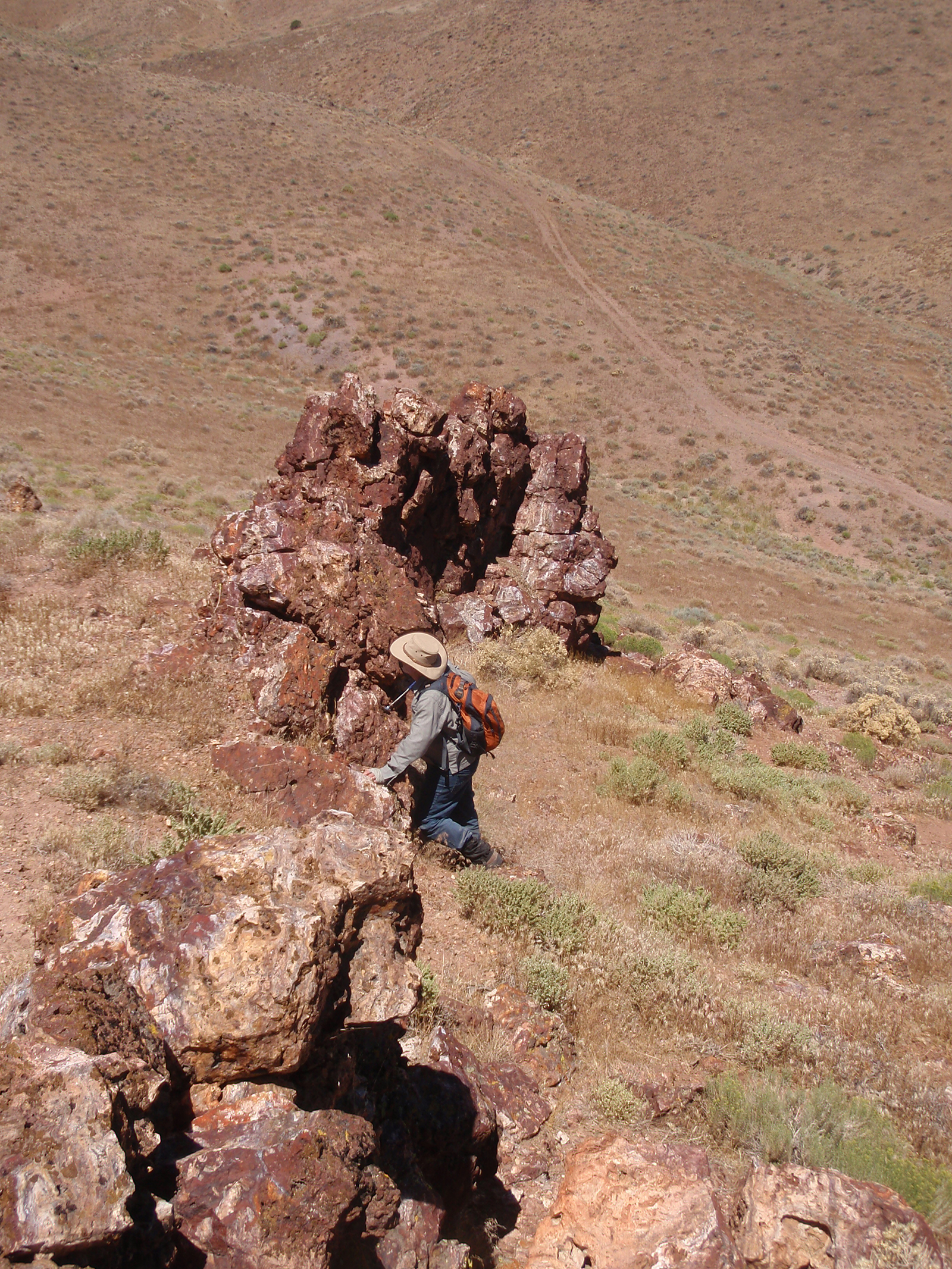
Sampling outcropping vein fragments and cross-cutting veinlets from likely deeper breccia erruptions assayed up to 1.0 g/t gold. The presence of low temperature silica flooding over a large area with low tempurature quarts veining and stockwork are indications of the top of a major quarts-aduleric precious metal system.
Gunpoint has an agreement with Newcrest Resources, a senior gold mining company, whereby Newcrest can acquire in multiple stages, up to a 75% interest in Appaloosa for cash payments totaling US$5 million, incurring US$35 million in exploration expenditures and delineating a minimum 1.0 million ounce gold resource.
In 2022, Newcrest completed a multi-process and systematic surface exploration program on Appaloosa including:
The exploration results summarized below confirmed the existence of a large, mineralized hydrothermal gold-bearing system.
During April-June, 2023, Newcrest drilled six core holes in the Central Target area at Appaloosa. Drilling returned halo intercepts of gold, silver and pathfinder elements consistent with the peripheral and upper zones of a low sulfidation epithermal gold-silver system. Four drill holes intercepted significant thickness indicating a shallow dipping, oxidized mineralized zone at the contact of two volcanic units suggesting lateral fluid migration.
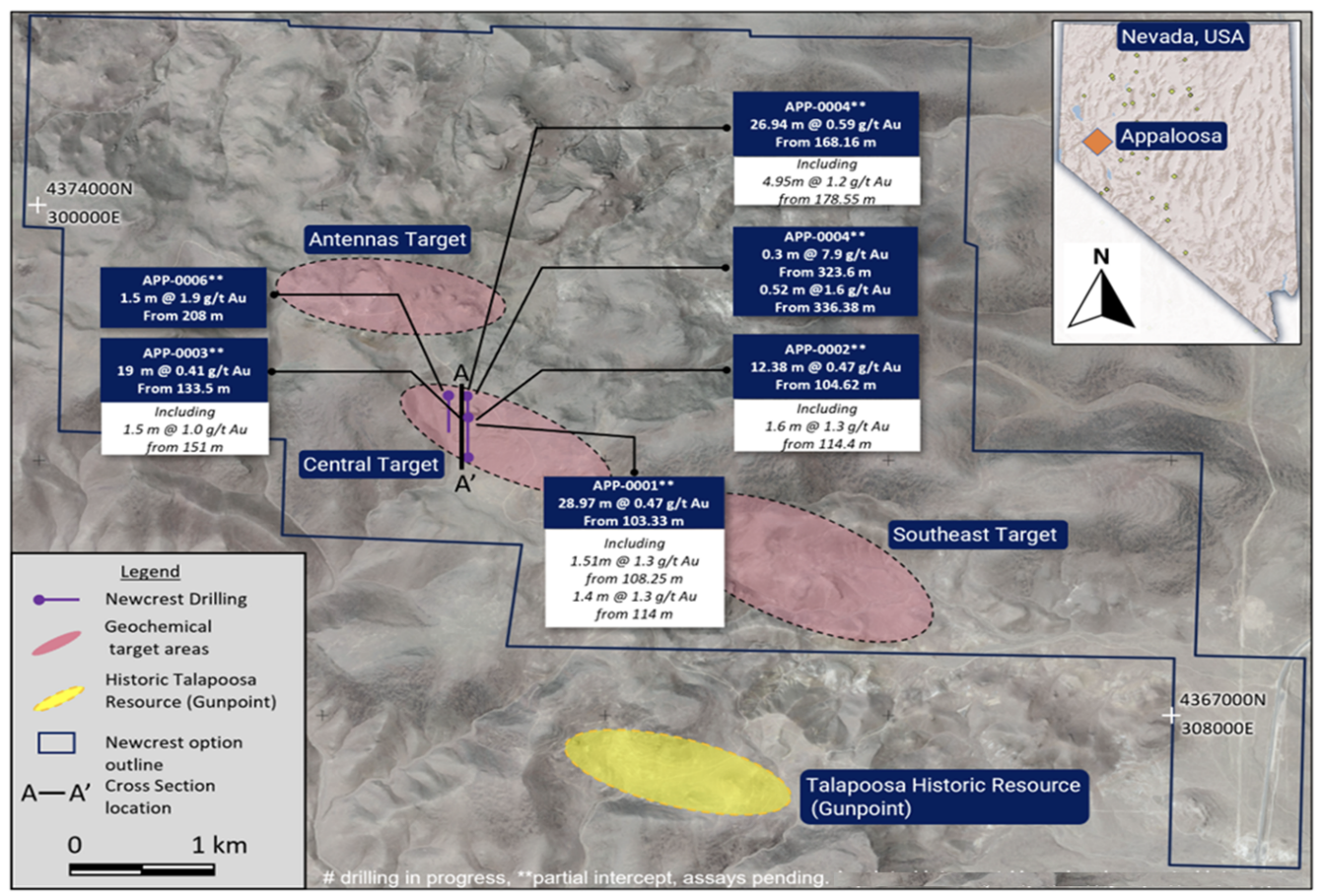
At a 0.2 g/t gold cut off, the four holes returned:
APP-0001 28.97 meters @ 0.47 g/t gold, 7.9 g/t silver
APP-0002 12.38 meters @ 0.47 g/t gold, 2.6 g/t silver
APP-0003 19.0 meters @ 0.41 g/t gold
APP-0004 26.94 meters @ 0.59 g/t gold, 12 g/t silver
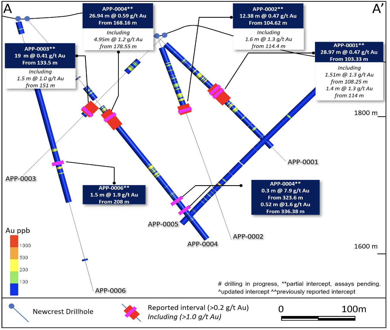
Evidence for deep high-grade zones is supported by 0.3 meters of 7.9 g/t gold and 30 g/t silver intersected on hole App-004 starting at 323.6 meters. Geophysics conducted over the property identified a northeast trending structural corridor intersecting the seven-kilometer-long Appaloosa trend. Drilling in ongoing to discover bonanza style mineralization in the epithermal system.